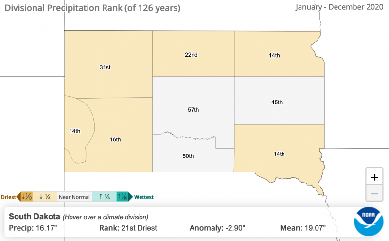
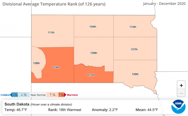
According to National Oceanic and Atmospheric Administrations’s (NOAA) National Center for Environmental Information, 2020 ranks as the 21st driest year for South Dakota with average total precipitation of 16.17 inches (Figure 1). It was also fairly warm with an average temperature of 46.7 degrees Fahrenheit, ranking 18th warmest of 126 years (Figure 2). Considering the widespread moisture issues much of the state faced in 2019, comparatively, 2020 was quite dry and warm.
At the current moment, we have the most drought statewide (per U.S. Drought Monitor, D1 category or worse) since February 2018. The 2020 drought conditions began in the northwest corner of the state, but at present, all counties in the state are rated to some degree on the dryness or drought scale. This hasn’t occurred since 2017.
2020 Regional Trends
If we look at different regions of South Dakota we can see some interesting trends.
-
Southwest: In 2020, the southwest region of South Dakota experienced the 16the driest year on record with 13.41 inches of total precipitation. That’s a negative 3.72-inch departure from normal. The region had an average temperature of 48.9 degrees Fahrenheit, ranking the 13th warmest for the region since 1895 (ranking 114 out of 126), showing a large swing in annual average temperature from 2019, the 14th coolest year for the region.
-
Central: Central South Dakota was near normal in annual precipitation with 17.05 inches in 2020, considering the 126-year average for the region is 17.49 inches. The region experienced the 18th warmest year on record, with an average temperature of 47.6 degrees Fahrenheit, several degrees short of the hottest year in the data set, 2012, with a 50.1 degrees Fahrenheit average temperature.
-
Northwest: Northwest South Dakota had been quite dry last year. The average temperature was 46.1 degrees Fahrenheit, above the 126-year average of 43.6 degrees Fahrenheit for the region. However, precipitation was below average, with an annual total of just 13.07 inches, a long ways from 2019’s 26.01 inches. These conditions were less than ideal for producers and created an early drought situation in many areas.
-
Northeast: The northeast part of the state saw a total of 17.18 inches of precipitation (below the 20.99-inch, 126-year average for the area) and experienced above average temperatures for the region. With an annual average temperature of 44.0 degrees Fahrenheit, 2020 ranked 110th out of 126 years (17th warmest); this is a stark contrast from 2019, when the region experienced an average temperature of 39.8 degrees Fahrenheit, ranking just 15th of 126 years.
-
Southeast: The southeast region of South Dakota had the 14th driest year on record with 18.29 inches of precipitation, just above 2012, which had 17.93 inches. This is also less than half of the 38.67 inches recorded in 2019. Precipitation for the year was 5.17 inches below average, the largest departure/difference from average of anywhere in the state. Annual temperature was the 18th warmest on record (since 1895), 2.0 degrees Fahrenheit above the long-term average.
Additional Insights
For more info in your region, visit the NOAA National Centers for Environmental information’s Climate at a Glance website or watch for reports and insights from our state climatologist, Laura Edwards.