A record wet August in several locations marked the end of South Dakota’s meteorological summer. The region with the highest total rainfall was in the northeast where several locations reported over twenty inches for the June through August summer season. Dry conditions developed in the south central region and held steady in the southwest. Statewide, average temperature for the three-month season was near normal, with some areas slightly above or slightly below normal.
Summer Climate Review
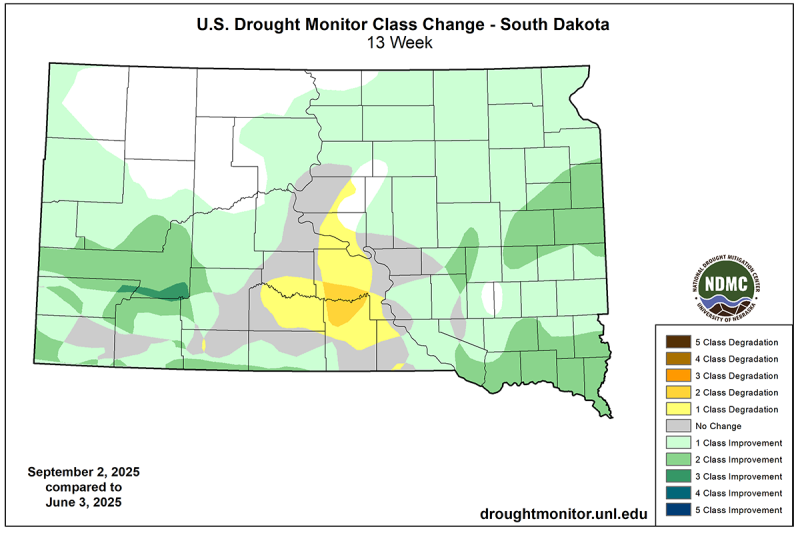
Dry and drought conditions improved or were entirely removed this season in most of South Dakota. Some locations in the state had their record wettest summer (June-August), based on preliminary data. The table below shows locations that had their wettest summer, and years of the climate record.
| Station Name (county) | June-August 2025 rainfall | Years of record |
|---|---|---|
| Maurine 12SW (Meade) | 12.98” | 50 |
| Watertown (Codington) | 17.91” | 132 |
| Wilmot (Roberts) | 24.52” | 82 |
| Waubay Natl. Wildlife Refuge (Day) | 16.84” | 73 |
| Britton (Marshall) | 24.11” | 132 |
| Sisseton (Roberts) | 13.70” | 27 |
The south central region became drier as drought conditions returned to this area in the summer season. Precipitation was around 50 to 90 percent of normal in this region, with spotty rainfall patterns and long dry stretches in between some rain events. This area of the state degraded one to two categories of drought on the US Drought Monitor.
Southwestern South Dakota held on to ongoing dry and drought conditions over the June through August months. Temperatures were above average, with the largest differences from normal of three to four degrees Fahrenheit in Fall River county. The warm temperatures contributed to the grip of drought in addition to the shortage of water.
Record Wet August
At some locations, not only was it the wettest summer on record, but also the wettest August on record. Preliminary data shows that Britton, SD reported 11.29” in August, which makes it the single wettest month in their climate history. The previous wettest month was June 2005 when this location had 11.11”. The records for this station go back to 1893. Other preliminary August rainfall records include:
| Station Name (county) | August 2025 rainfall | Years of record |
|---|---|---|
| Britton (Marshall) | 11.29” | 132 |
| DeSmet (Kingsbury) | 9.96” | 132 |
| Huron (Beadle) | 6.93” | 144 |
| Milesville 5NE (Haakon) | 6.90” | 114 |
| Wilmot (Roberts) | 8.70” | 82 |
| Kirley 7N (Haakon) | 6.77” | 55 |
| Maurine 12SW (Meade) | 7.38” | 50 |
Impacts
Exceptionally wet areas in the northeast have had some flooding. In June, the Big Stone, SD/Ortonville, MN area experienced flooding on the Little Minnesota and Whetstone Rivers and Big Stone Lake. Over the course of the summer, agricultural fields in the region have accumulated water in low lying areas, drowning out some portions of fields that had been planted in the dry spring season. In the prairie pothole region, aerial photography has shown many low areas where row crops have been drowned out.
The increased rainfall and water on the landscape have also contributed to elevated humidity in combination with moisture from the south. Most of eastern South Dakota has had record high humidity for the two months of July and August combined. The increase in humidity has caused issues in drying down hay, increase in some rust diseases on corn and foliar disease in lilacs and some tree species. Some molds have been reported in backyard gardens as well.
Some ranchers have had to move cattle out of saturated and flooded pastures due to potential for foot rot diseases.
The benefits of the wet summer have come in the way of more cutting of alfalfa, additional cutting of hay and good production of forage and grass in pastures. Water quality and quantity in most stock ponds have improved compared to last year’s drought conditions. Early reports indicate that pheasants and some large game animals have thrived since the dry winter and spring season, with plentiful vegetation cover from predators and access to food and water sources.
Climate Outlook for September
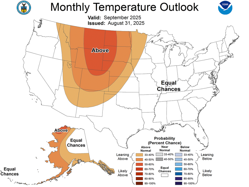
On August 31, the NOAA Climate Prediction Center released their temperature and precipitation outlooks for September. South Dakota is favored to have warmer than average temperatures for the month overall. The middle portion of September is projected to have a warm pattern establish over the area, so that may be enough to lean the entire month above normal.
As for a fall frost prediction, a widespread early frost does not seem to be likely this year. Given this temperature outlook, and the amount of humidity in the environment, a near normal to late frost is more likely to occur.
The precipitation outlook for September is less certain. Most of the state has equal chances of wetter, drier, or near average for moisture for the month. The southeastern corner has slightly increased chances for a wetter month than usual, but there is not high confidence in this area.
One challenge coming this fall is how quickly can field and crop conditions dry down in the east to allow harvest activities to progress, and will grain dry down sufficiently well before harvest or will there be a need for mechanical drying after harvest? These are going to be very local issues, but there is no doubt that a wet and humid summer has set up a potentially challenging harvest season for row crops. On the other hand, good late summer and fall soil moisture will set the stage for potential success in pasture and range production in 2026.