A very warm winter is just about to end as we look ahead towards what’s to come in the spring season. And what’s the story with El Niño this spring?
Spring seems to have come early this year with the majority of our snowpack having melted in early February, about four to six weeks earlier than the typical snowmelt season. As of this writing, all of eastern South Dakota experienced average temperature between 15 and 20 degrees F above average for the first three weeks of the month. Additionally, soils have already thawed through the profile in the southern half of the state.
The February 15, 2024 temperature outlook for March and through May, released by NOAA’s Climate Prediction Center, shows that chances are slightly increased for warmer than average temperatures through the spring season for most of the state. This applies primarily to northern South Dakota and the east central region. In southern South Dakota, there are equal chances of warmer, cooler, or near average temperature for both the month of March and the three-month period of March through May.
This temperature outlook is consistent with a typical spring season that follows a strong El Niño winter. In El Niño winter seasons, the state often experiences warmer than average temperatures. As El Niño wanes, as is the case this year, the jet stream pattern that brings warmer temperatures starts to change and becomes less reliable as a forecast tool. The current El Niño is expected to end sometime in the next two to three months, with a transition to ENSO-neutral (neither El Niño nor La Niña) for the summer season.
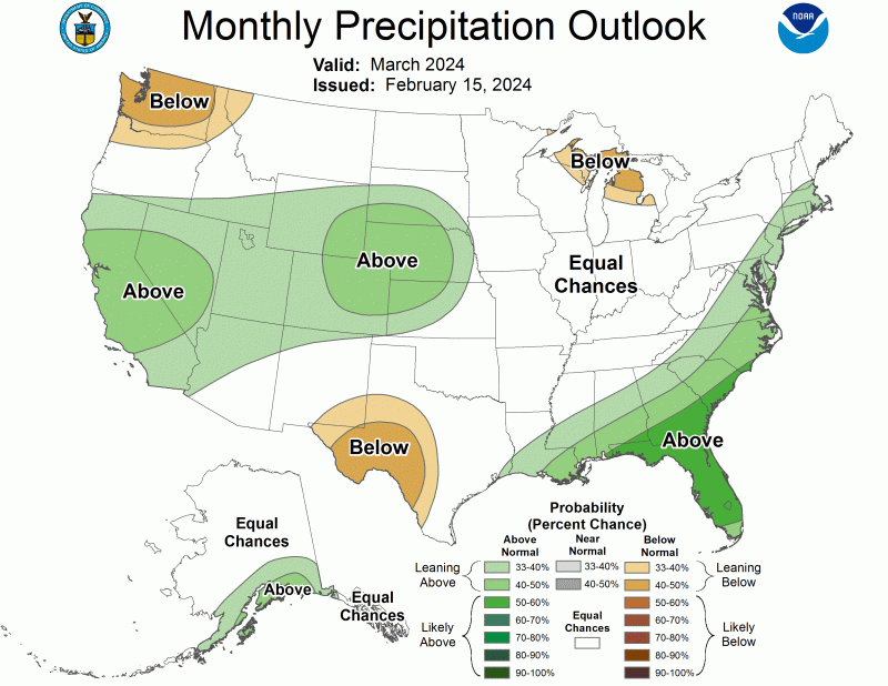
The precipitation outlook shows increased chances of wetter than average conditions in southwestern and south central South Dakota in the month of March. For the three-month period of March through May, the entire state has equal chances of wetter, drier or near average precipitation. There are mixed signals among computer climate models as to what our region can expect for springtime precipitation.
With soils thawing earlier than normal and warm air temperatures possible through the spring, thoughts turn towards spring farming field work and lawns and gardens. It is possible, if not likely, that outdoor activities could start earlier this year than in a typical year, and almost certainly earlier than last year. A period of cold weather can still pass through the region, but at this time it would seem to be short lived with warmer temperatures generally expected to dominate in the next one to three months.
There are some areas of drought in South Dakota. A newly emerged area of drought can be found in the Black Hills, primarily driven by lack of snowfall and warm temperatures. Even though this “snow drought” has affected snow sports and recreation, this can also have the added negative impacts of limited runoff into reservoirs and increasing fire risk with shallow or no snow cover to stop or limit fire activity. There is some reserved optimism with the March precipitation outlook that spring moisture can alleviate drought concerns before the growing season really starts in earnest.
In the southeast, a multi-year dry period is lingering with dry soils deeper in the profile, record to near-record low groundwater levels, and virtually no runoff from snowmelt. The soil’s memory of a long-term drought can be slow to change. The good news is that this area experienced another snow storm in mid-February that will work to maintain the shallow soil moisture that was gained in the first snowmelt period in early February. Fire is also a concern in this region due to dry sloughs and ample dry vegetation that is exposed to burn in this “shoulder season”, as we await the traditional wet months of April through June. This region is likely to rely more on timely precipitation to create good growing conditions this season.
All in all, it’s not too early to be planning and preparing for your spring field work and lawn and garden work. It turns out that Punxsutawney Phil may have just been right this year with a forecast of an early spring.