The flooding in March and April of 2019 has been among the worst that South Dakota has experienced in recent decades. Substantial snowpack on the plains, with deep frozen and saturated soils, led to high flood potential. The heavy rain and blizzard on March 13-14, 2019 brought an abrupt end to the snowpack in Southeastern South Dakota and produced record or near record flooding along the rivers and across the region.
Current River Levels
As April unfolds, major flooding continues along the Eastern rivers. The James River is at crest in Brown county the first week of April and will slowly recede while maintaining flood level for much of April. This is not unusual during spring flood years, as this river moves water very slowly southward to the Missouri River.
The reservoirs in the Missouri River are rising as well. The US Army Corps of Engineers issues daily updates on river and reservoir status. They began the snowmelt season with over 90 percent of flood control capacity available in their six reservoirs. Gradual releases from the dams will manage the reservoir levels throughout the system. This year, snowpack in the Northern Rocky Mountains is just near average. The forecast runoff from the entire river basin is expected to be above average, due to the amount of snowmelt in the plains and any additional rainfall that will runoff of saturated soils.
Fortunately for much of the rest of the state, rivers have crested and have receded. What remains, however, is a risk of flash flood. Thunderstorms can bring heavy rain in the spring season, which will runoff quickly over wet soils.
Planting Season Outlook
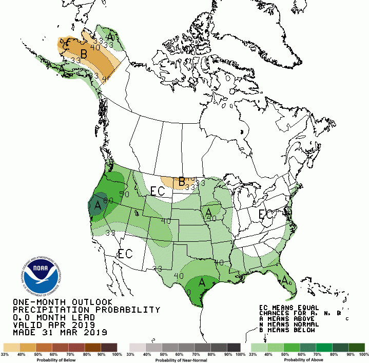
The long-term outlook for April favors wetter conditions to continue for month overall. Mid-month especially appears to favor wetter and cooler conditions, compared to average for this time of year. This will make planting season challenging at best, as soils are very wet and cold from the long winter season. As of April 5, frost depth in the Northeast was about three to four feet deep. Patchy snow cover remained across the Region to prevent thawing. Soils in Central and Southern areas are beginning to thaw but are saturated through the profile. Planting progress will be slow and intermittent, in order to wait for windows of opportunity of relatively dry and warm conditions to allow field work. The Southeastern area in particular has had many recent wet springs but have often come to realize some good yields as well. It is too early to determine the impact of this cool, wet spring on final production.
Across the state, the ample moisture has brought surface water to fill stock ponds and has the potential to produce good grass and forage for grazing. April is a key period for precipitation for grass production, so there may be a silver lining after many of the struggles with unfavorable cold and wet weather for calving season.