The better part of June is behind us, so we are looking ahead to July and what lies ahead for our farms and gardens. The recent run of warm temperatures across South Dakota and exceptional dry conditions in the central and east have accelerated drought concerns.
Drought Update
As of June 15, just over 25 percent of South Dakota was in moderate or severe drought. Another 45 percent is abnormally dry. Concerns about dryness and drought have eased in some areas of western South Dakota while they have increased in the central and east. From mid-May to mid-June, most of central and eastern regions have measured less than 50 percent of average rainfall, with many locations reporting less than 25 percent of average rainfall, in what is typically our wettest time of year.
Drought impacts from this dry period have been amplified by very warm temperatures, especially in the northern counties. For the period from mid-May to mid-June, the average temperature was eight to ten degrees above typical for that period. This amounts to crop stress and loss of soil moisture, with small grains currently experiencing the worst losses, particularly in oats and barley.
July Outlook
Precipitation
For the month of July, some good news lies ahead for growers across the state. The outlook published on June 15 from National Oceanic and Atmospheric Administration’s Climate Prediction Center (abbreviated as NOAA Climate Prediction Center) indicates increased chances of wetter than average conditions in the month of July (Figure 1).
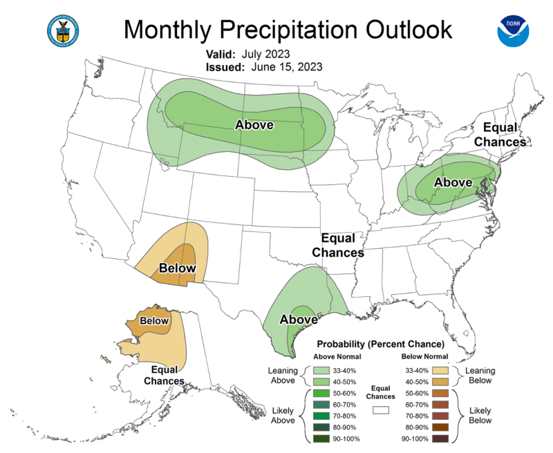
This, coupled with a climate pattern that does not particularly lean towards warmer temperatures, could bring some relief to corn and soybean farmers and gardeners. A wetter pattern in July would be too late for some small grains and pasture and range areas that have already experienced severe drought impacts, but optimism lies in some of the summer row crops and some western areas.
Temperature
The temperature outlook shows equal chances of warmer, cooler or near-average temperature for the month of July in South Dakota. As crops and gardens are developing in July, this can be a critical time for pollination and setting fruit. Temperatures may swing warm and cool in the next month, but it does not appear likely for the state to have another month-long period with very warm temperatures. The far southeast corner may have slightly enhanced chances of warmer than average temperatures, but there is not a lot of confidence from the forecasters.
July Through September Outlook
Precipitation
For the next full three-month season, odds lean slightly towards wetter conditions for the remainder of the season. This is somewhat driven by a developing El Nino pattern that is originating in the tropical Pacific Ocean. As fall season approaches, historical data points to a slightly wetter pattern in the fall season for our region.
Temperature
At the same time temperatures will have equal chances of warmer, cooler or near-average for the three months of July through September. What this means for South Dakotans is a potential to recover from the current short-term drought. The seasonal drought outlook, also from NOAA’s Climate Prediction Center, points to an improvement in drought conditions in the coming three months. With summer being a season with the highest impacts, we may still see some fluctuations up and down in drought severity from week to week, depending on what areas receive rainfall, how much, and over what time period.