Written with contributions by Karishma Kumari, Salma Mirzaee and Ahmed Abdalla.
Integrated Precision Agriculture (PA) decision-making tools, including data collection and analysis platforms, have transformed our agriculture today by optimizing crop management and increasing productivity. Aerial imagery, for example, can provide farmers, agronomists, and policymakers with real or close-to-real-time, accurate, and actionable data for optimizing practices and managing resources effectively, leading to sustainability. Aerial imagery is a powerful tool enabling efficient monitoring of large areas that supports effective decision-making by early detection of crop issues (such as water or pests’ stresses and nutrient deficiencies), to enhance sustainable practices by optimizing. The common types of aerial imagery for crop assessment are:
Satellite-Based Imagery
Images captured by satellite imagery provide large-scale coverage with frequent revisit times depending on the satellite. The list of satellites used in agriculture, based on their resolutions (Fig 1), are as follows:
Resolution (up to 10m²)
GeoEye-1 (Geoeye), WorldView-3 and 4 (WorldView-4), Pléiades (Airbus Satellites), Planet Labs (Planet), are common satellites with multispectral imageries providing crop health monitoring, soil analysis, and infrastructure mapping for crop stress detection, detecting fine-scale agricultural patterns, pest hotspots, and irrigation planning. These are commercial (Paid) satellite imagery. However, Planet imagery access for some datasets can be free through specific programs or portals like USGS Earth Explorer.
Resolution (10m² to 30m²)
Sentinel1-2 and Landsat 8 & 9 (USGS/NASA) aerial imagery products enable the monitoring and assessment of crop health, enhancing pest detection, optimizing variable rate input applications, improving crop management, and promoting environmental quality through more efficient input usage and targeted optimizations.
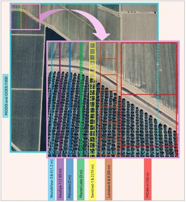
Resolution (Above 100m²)
Moderate Resolution Imaging Spectroradiometer (MODIS/NASA), Project for On-Board Autonomy – Vegetation (PROBA-V), and Geostationary Operational Environmental Satellites (GOES), can provide land cover and vegetation growth information with essential data for applications such as land use, crop monitoring, famine prediction, and global environmental and climate studies, classified as low-resolution with coarse resolutions compared to higher-resolution systems.
Airplane-Based Imagery
Airplane-based imagery refers to the collection of sensing data captured from manned airplanes or other aircraft equipped with cameras and sensors flying over farmland providing high-resolution images compared to satellite-based imagery. The higher spatial resolution of captured images by airplanes compared to satellite imagery, can result in detailed sensing, mapping, and monitoring, in precision agriculture. Some advantages of airplane-based imagery are: a) customizable flight paths to target specific locations with predefined routes, ensuring coverage of areas that may be difficult to monitor using satellites, b) they can be timed for clear weather conditions and useful for areas with frequent cloud cover as well as on-demand data collection, c) airplane can carry a wide array of sensors (e.g., optical cameras, LiDAR, Thermal sensors, Multispectral and Hyperspectral) for detailed vegetation analysis and mineral exploration. On the other hand, logistical coordination and flight permissions, limited coverage, weather dependency, and higher cost compared to satellites, are some of the disadvantages of the airplane-based imagery and making it less efficient for global-scale monitoring.
Drone (UAV) Imagery
Unmanned Aerial Vehicles (drones) equipped with multispectral, RGB, thermal, and hyperspectral cameras and sensors, highly adaptable to specific areas and conditions, can capture very high spatial resolution (centimeter-level precision). Usually, drones are cost-effective for small to medium-sized farms and can be used in real-time or on-demand detecting fine-scale variability in crops and soil. The limited coverage area compared to satellites and airplanes, regulatory restrictions on drone flights in some areas, required expertise in flight planning, data acquisition and processing are some of the challenges in using the drones. Different types of UAVs used in agriculture based on their capabilities and the specific are:
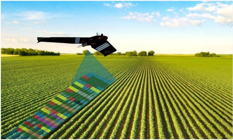
Fixed-wing drones
Similar to small airplanes with wings and can cover large areas efficiently. Specifics about the fixed-wing drones are large-scale field mapping, crop health monitoring, topographic surveys, and long flight durations to cover large areas with high efficiency for large farms. Limited hovering capability, launch and landing area requirements, and higher cost are some challenges in using fixed-wing drones (Fig 2).
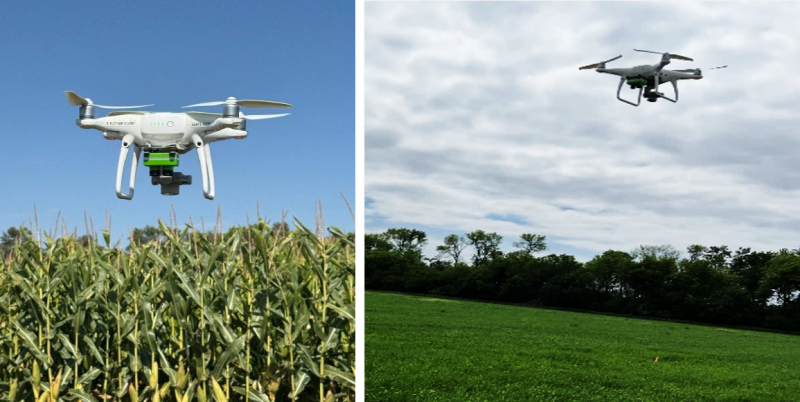
Rotary-wing (multi-rotor) drones
The drones with multiple rotors (e.g., quadcopters, hexacopters) are highly maneuverable for easier takeoff and landings that can hover and fly at low altitudes for more precise data collection (Fig 3). The flight time for these drones is shorter (20-40 minutes).
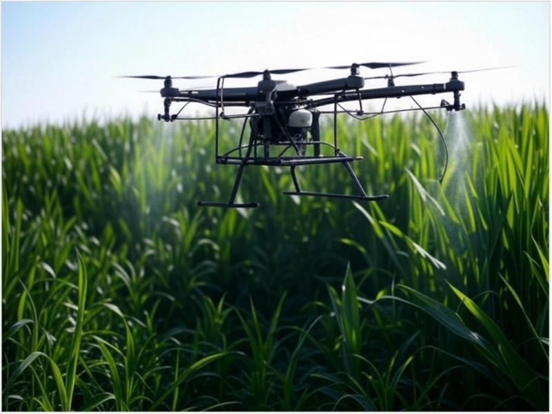
Spraying, seeding, and spreading drones
With higher payload capacity, these drones are designed to perform variable rate applications and precisely apply pesticides, herbicides, and nutrients. Used for pesticide, herbicide, and fertilizer applications, replacing traditional spraying methods. Heavy-duty rotary-wing spraying drones can carry large payload. They also can be equipped with AI-powered spraying and terrain-following system for improving the efficiency of large-scale spraying. This approach can lower the labor costs and help to reduce chemical waste (Fig 4).
Livestock monitoring drones
These UAVs can be used for health monitoring, herd & livestock tracking and pasture assessment for improving the management.
Detailed breakdown of recommended drones for different applications
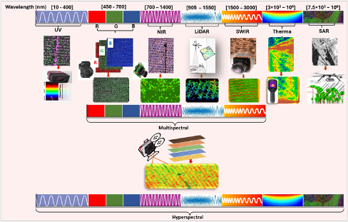
UAVs can be equipped with different types of imaging sensors, used for aerial surveys to assess crop health and other related information, herd & livestock tracking that can cover large areas quickly capturing high-resolution imaging. The primary types of drone imagery cameras used in agriculture are as follows:
- RGB (Red-Green-Blue), standard color images are like what human eyes see and can be used for aerial photography, mapping, visual inspection, surveying, media, and entertainment.
- Multispectral cameras can capture data in multiple spectral bands (typically visible and near-infrared). Normalized Difference Vegetation Index (NDVI) index used in precision agriculture revealing information related to vegetation health, identifying crop stress, and soil moisture levels, is a product and example of captured data in multiple spectral bands.
- Hyperspectral imagery with hundreds of narrow spectral bands across the electromagnetic spectrum can be used for research in environmental monitoring, precision agriculture, pollution detection, and material identification. The high spectral resolution enables detailed material composition analysis.
- Thermal Infrared (TIR) imagery can provide temperature signature variations in objects and surfaces.
- Near-Infrared (NIR) imagery captures reflectance in the near-infrared spectrum can provide information related to vegetation health monitoring, water stress detection, and forest biomass analysis.
- LiDAR (Light Detection and Ranging) sensors use laser pulses to create detailed 3D point clouds of terrain and structures.
- Synthetic Aperture Radar (SAR) imagery uses radar waves to penetrate clouds, vegetation, and even ground surfaces.
- Shortwave Infrared (SWIR) imagery with shortwave infrared light, useful for identifying materials and moisture content, can detect chemical compositions and moisture variations.
- Ultraviolet (UV) imagery uses UV radiation to detect surface changes and organic compounds that can reveal details invisible in visible light.
Each type of UAV imagery can be used for specific applications, depending on the sensor technology and intended analysis (Fig 5).
Future Work and Challenges
While aerial imagery is revolutionizing precision agriculture, data processing and handling vast amounts of data require advanced computing power and expertise. Also, high-resolution satellite imagery and sophisticated drones can be expensive for small-scale farmers. Using drones is subject to following airspace regulations and limitations, in addition to adverse weather conditions and cloud cover that can affect image quality and data collection.
Despite these challenges, aerial imagery has a promising role in transforming precision agriculture by providing farmers with valuable information for optimizing farm production and improving environmental quality. By harnessing the power of drones, satellites, and AI-driven analytics, agriculture is moving toward a future of enhanced precision and productivity.