Climate
Report by Laura Edwards, SDSU Extension.
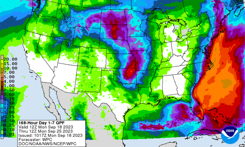
Across South Dakota, some localized storms and showers brought rain in many parts of the state last week. Weekly total rainfall ranged from less than one-tenth to just under an inch. The highest rainfall totals were in small areas, amounting to about three-quarters of an inch at individual stations in Sanborn, Campbell, Brown, Marshall and Roberts counties. The regions with no measurable rainfall were along the southern tier of the state.
The thermometers rose again this week, with high temperatures peaking in the 80 to 90+ degree Fahrenheit range at many locations in South Dakota on September 30 and October 1. Weekly average temperatures were two to ten degrees above typical for this time of year across the state. The eastern counties were warmer (compared to normal) than the west.
Weather
Report by Darren Clabo, South Dakota Mines.
Forecast Highlights: High temperatures today will range from the mid-60s west to near 90 degrees Fahrenheit over the southeast. Breezy southerly winds are expected over the eastern half of South Dakota, while western South Dakota sees light southeasterly winds. Widespread showers and thunderstorms are expected this evening and will likely continue overnight tonight. More showers and thunderstorms are expected tomorrow as well. High temperatures tomorrow will be in the 60s and 70s, warmest across the southeast, and southwest winds will be seen statewide. Wednesday and Thursday will be dry, with high temperatures in the 50s and 60s. Thursday will be windy statewide with gusts out of the northwest from 30 to 45 mph. Dry conditions will persist Friday through the weekend. High temperatures on Friday will be in the 40s and 50s, while temperatures on Saturday and Sunday will climb into the 60s and 70s. Minimum RH will stay above 30% all week.
Potential for Critical Conditions: Critical conditions are not expected, but the windy conditions today (southeastern South Dakota) and Thursday (statewide) will locally elevate the fire danger.
Fire/Fuels
Report by Darren Clabo, South Dakota Mines.
No large fires have been reported recently. Fuels continue to cure out, but ERCs are still at or below average.
ERC maps will not be available until NFDRSv4 becomes fully operational.
Next Update: Tuesday, October 10, 2023