As winter slowly fades away, temperatures are warming, and spring is in the air. Small grain planting has already begun for some of our southern areas, while others in the north are waiting for drier and warmer soils. Gardeners are planting potatoes and getting lawns cleaned up.
Temperature
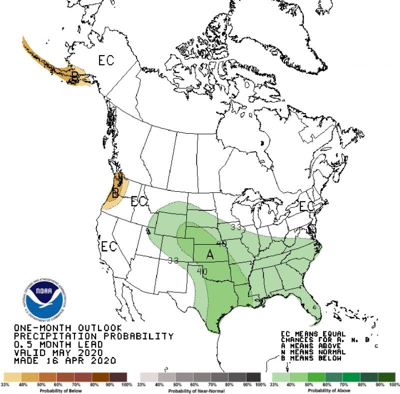
On April 16, NOAA’s Climate Prediction Center released their climate outlook for May and the coming three-month period of May through July. There is a lot of uncertainty in the temperature outlook for the next one-to-three months in the Northern Plains Region. The temperature outlook for both May and the May through July periods show equal chances of warmer, cooler or near average temperature for South Dakota.
The uncertainty in our region is due to at least a couple of factors. The climate models have shown some disagreement in the late spring and early summer, with some showing warmer and some cooler in the months ahead. Another factor in our region is the very wet soil conditions we have now, from both snowmelt and carryover from 2019. Wet soils tend to favor cooler temperatures near the surface, as it takes more solar energy to warm those soils than it does for dry soils.
Precipitation
The precipitation outlook for both May and the May through July period indicate increased chances for wetter than average conditions in the coming months for South Dakota. Confidence in this outlook increases later in the spring/early summer season. Over the last several months, climate models have been consistent in favoring wetter than average conditions in the spring season. Wetter conditions could bring a few challenges to spring season planting activity by reducing time to work in the fields, to treat with early season herbicides and apply fertilizer, or add to challenges with wet soils that struggle to dry enough for heavy equipment to pass through.
The risk of widespread major flooding has waned with the slow and steady snowmelt this year. The northern tier of the state has enjoyed dry conditions over the last couple of months, which has prevented additional moisture on the landscape and in the soils. Soils statewide remain very wet for this time of year, so a heavy rain event or thunderstorm could bring a local area flash flood event in most areas of the state. Without a long warm and dry period, soils will be slow to dry as we enter our spring planting season.
For gardens and row crops, there will be windows of opportunity to plant, fertilize and treat weeds and other pests. Field and flood conditions are much better this year than in 2019, even though low-lying areas may still be underwater or saturated. Watch weather conditions closely, and the SD Mesonet can help track soil temperature and moisture as you prepare for field work and lawn and garden activities this season.