Written by Grace White under the direction and review of Laura Edwards.
Drought Conditions
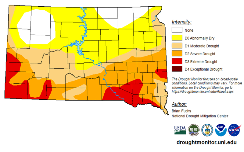
Today, 54% of South Dakota is in Drought, around a 2% increase from last week and a 12% increase in the last three months. According to the U.S. Drought Monitor, severe to extreme drought conditions continue to impact 34% of the state. Southern South Dakota remains the most impacted by drought conditions. Drought is impacting an estimated 635,540 residents, increasing by more than 10,000 people from last week. This means that nearly two-thirds of South Dakota's population is currently affected by drought.
Precipitation data from the High Plains Regional Climate Center supports the Drought Monitor assessment. Over the past 7 days, East-central South Dakota has received the most rainfall, above 0.7 inches in some areas. On the other hand, Southwestern areas have received near-zero total rainfall. Much of the state received around 0.1 to 0.4 inches of precipitation. Since the start of the month, the driest areas have been Western and Southeastern South Dakota, with around 0-0.5 inches of rain. East Central South Dakota has received the most precipitation, with more than 3.5 inches of rain in some parts.
This was a cold week in South Dakota; in the past 7 days, the whole state has had below-normal temperatures. West Central South Dakota was the coldest, with temperatures averaging around the low 50s. The warmest areas included the Southeastern and Central parts of the state, with temperatures averaging in the upper 60s. More than half of the state was 3 degrees or more below normal temperatures for this time of year.
The National Integrated Drought Information System for the Upper Missouri River Basin provides valuable soil moisture data. NIDIS measures soil moisture based on how easily vegetation can access it. Southern and western South Dakota report many areas with low soil moisture accessibility, with isolated pockets of adequate or surplus moisture mostly in Central and Northeastern South Dakota. In the past week, soil moisture accessibility has declined the most in Northern and South Central areas of the state. These drier topsoil confirms the below-normal precipitation trends we have seen across South Dakota.
Temperature and Precipitation Outlook

On June 18, 2026, NOAA’s Climate Prediction Center released their latest climate outlook for July and the coming three month season through September. The next one to three months are projected to hold a pattern of warmer than average temperatures in the west, south and east. Over the north central states, near to below average temperatures are slightly favored during this same period.
In the month of July, chances lean slightly towards drier than average conditions across northern South Dakota. Elsewhere in the state, there are equal chances of wetter, drier and near average precipitation in July. For the three-month period of July through September, there is no clear consensus in the climate models for the precipitation outlook. Equal chances of wetter, drier or near normal moisture are projected for the state.
Drought conditions are predicted to continue through the remainder of the growing season for those areas in South Dakota that are currently experiencing drought. Drought development is unlikely in the north central/northeast region, despite the odds favoring drier conditions in July. This area would need to dry out very quickly, perhaps accompanied by very warm temperatures, to develop drought conditions. Local conditions may ease or degrade with small scale rain or storm showers, but large scale improvement is not expected at this time. The season for cool season grasses is coming to an end, and there is limited to no improvement possible now with these vegetation species in pasture and grasslands. Warm season grasses, spring planted row crops, established lawns and gardens may still be able to do well with timely rainfall during the next three months.


