Written by Grace White under the direction and review of Laura Edwards.
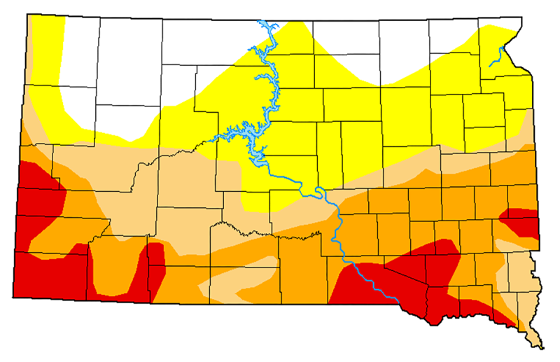
According to the June 11, 2026 U.S. Drought Monitor, 53% of South Dakota is currently in drought, a notable increase from the 34% land cover recorded at the start of the season. Extreme Drought conditions currently encompass 11% of the state, compared to just 1% at the beginning of spring. These conditions are strongest primarily in the southern half of the state, impacting approximately 623,996 residents, or roughly two-thirds of the state’s population, highlighting the ongoing and expanding impact of drought across South Dakota.
Precipitation and temperature data from the High Plains Regional Climate Center support the drought assessments. Over the past 7 days, the majority of the state recorded 0.5 to 1 inch of rainfall, which is below historical averages for this period. Minor exceptions occurred north of the Missouri River and in eastern South Dakota, where isolated pockets recorded 0 to 1 inch above normal precipitation. Over the past 90 days, a persistent precipitation deficit affected most of the state, peaking at 7.5 inches below normal in southeastern South Dakota, while central and northern pockets registered 0 to 3 inches above normal rainfall.
Temperature data have further intensified these drought conditions. Over the past 7 days, the entire state experienced above-normal temperatures, with the greatest departure occurring in eastern and southwestern South Dakota at 6 to 10°F above normal. This aligns with the 90-day trend, which shows temperatures consistently above normal. Local areas experienced 0 to 2°F below normal in central South Dakota.
The National Integrated Drought Information System data for the Upper Missouri River Basin assess soil moisture based on how readily vegetation can access it. Much of western South Dakota has low to very low soil moisture, while the northern and central areas have mostly adequate moisture. The southern portion of South Dakota has mixed soil moisture levels, ranging from low to adequate. Locations in northern and east/west leaning central have a surplus of soil moisture today. Over the past week, the greatest declines in soil moisture occurred across central, western, and southeastern South Dakota.
The Climate Prediction Center outlooks indicate a possible shift toward cooler, wetter conditions. The 6 to 10 day forecast expects higher chances for below normal temperatures across much of the state. Except for the southwest, which has higher chances for warmer temperatures. During this same period, precipitation chances lean above normal across most of South Dakota, with the northeastern corner having equal chances for above, below or usual precipitation. The 8 to 14 day outlook favors lower temperature chances statewide, with the southwest having equal chances for above, below or normal temperatures. Precipitation chances favor greater than usual precipitation.